
Site Reconnaissance: Difference between revisions
Rmanwaring (talk | contribs) No edit summary |
Rmanwaring (talk | contribs) No edit summary |
||
| Line 38: | Line 38: | ||
"In areas where the [[soils]] and geologic conditions are well known, a detailed investigation may not be necessary for small, low-hazard structures. For such structures, the preliminary investigation needs to be sufficiently detailed to provide relevant information on site materials, conditions, and engineering characteristics for planning, design, and cost estimates."<ref name="NEH_CH2" /> | "In areas where the [[soils]] and geologic conditions are well known, a detailed investigation may not be necessary for small, low-hazard structures. For such structures, the preliminary investigation needs to be sufficiently detailed to provide relevant information on site materials, conditions, and engineering characteristics for planning, design, and cost estimates."<ref name="NEH_CH2" /> | ||
==[[Best Practices Resources]]== | ==[[Best Practices Resources]]== | ||
{{Document Icon}} [[National Engineering Handbook: Chapter 2 - Engineering Geologic Investigations | National Engineering Handbook: Chapter 2 - Engineering Geologic Investigations, NRCS, 2012]] | {{Document Icon}} [[National Engineering Handbook: Chapter 2 - Engineering Geologic Investigations | National Engineering Handbook: Chapter 2 - Engineering Geologic Investigations, NRCS, 2012]] | ||
{{Document Icon}} [[Engineering Geology Field Manual 2nd Edition, Volume 2 | Engineering Geology Field Manual 2nd Edition, Volume 2 (USBR, 2001)]] | |||
{{Document Icon}} [[National Engineering Handbook: Chapter 2 - Engineering Geologic Investigations | National Engineering Handbook: Chapter 2 - Engineering Geologic Investigations (NRCS, 2012)]] | |||
{{Document Icon}} [[Geophysical Exploration for Engineering and Environmental Investigations (EM 1110-1-1802) | Geophysical Exploration for Engineering and Environmental Investigations (EM 1110-1-1802) (USACE, 1995)]] | |||
{{Document Icon}} [[Design of Small Dams | Design of Small Dams (USBR, 1987)]] | |||
{{Document Icon}} [[Earth Manual Part 1 | Earth Manual Part 1 (USBR, 1998)]] | |||
==[[Trainings]]== | ==[[Trainings]]== | ||
Revision as of 22:03, 2 November 2022
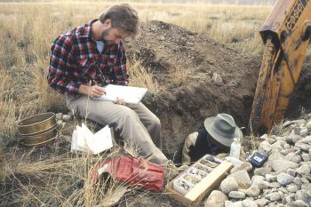
Geologic Reconnaissance
|
| Soil Survey |
"The results of the geologic reconnaissance are used to assess the need for more detailed investigation and whether additional technical expertise is needed."[1]
"Geologic reconnaissance includes the collection and review of existing data. Characteristics of the site should be assessed, including geomorphology, topography, drainage, and other conditions that might affect the suitability of the site for its intended use and for potential impacts on natural resources. Site visits may be conducted to assess the suitability of the area for the proposed project, verify the accuracy or adequacy of existing information, and identify significant gaps in information needed to continue with the design."[1]
"The engineering properties of soil and rock materials need to be evaluated. Consideration of how the operation of the proposed project, structure, or practice might affect local natural resources must be addressed. Logistical concerns, such as access, that may affect future activities also need to be addressed. Existing data and information should be reviewed before field investigation. Data and information sources include geologic maps, topographic maps, well logs, aerial photographs and other imagery, soil surveys, water and mineral resource reports, and other reports and information sources that pertain to the area of the site and the nature of the project."[1]
"Limited on-site investigations may be conducted to assess the feasibility and suitability of the site, to recognize hazards, to verify the accuracy or adequacy of existing information, and to identify significant gaps in information needed to continue with design. Data gathered during the reconnaissance are primarily descriptive and should include the following:
- general geology of the site: surface and subsurface earth materials;
- geologic conditions that may affect erosion and sedimentation;
- geologic conditions that may influence groundwater movement and recharge;
- general character of topography and stream system;
- engineering properties of soil and rock materials;
- presence and activity of faults;
- general relationship between the geologic conditions at the site and known or typical design requirements for the proposed conservation practice or structure;
- known or projected mining activities and oil or gas extraction."[1]
Preliminary Site Investigation
"A preliminary investigation consists of a field study and a review of available literature and maps relating to regional geology and physiography. The general physical feasibility of the site is assessed and specific questions to be answered during the design process posed. Field studies should include a thorough inspection of outcrops, cut banks, and other surface exposures and an examination of erosion conditions, landslides, seeps, springs, and other conditions on and adjacent to the project site."[1]
"The geologist and the designer should discuss geologic conditions that may influence the design, construction, cost, and functioning of the proposed structure. If these conditions appear adverse, a more intensive investigation may be required to assess site feasibility."[1]
"In areas where the soils and geologic conditions are well known, a detailed investigation may not be necessary for small, low-hazard structures. For such structures, the preliminary investigation needs to be sufficiently detailed to provide relevant information on site materials, conditions, and engineering characteristics for planning, design, and cost estimates."[1]
Best Practices Resources
![]() National Engineering Handbook: Chapter 2 - Engineering Geologic Investigations, NRCS, 2012
National Engineering Handbook: Chapter 2 - Engineering Geologic Investigations, NRCS, 2012
![]() Engineering Geology Field Manual 2nd Edition, Volume 2 (USBR, 2001)
Engineering Geology Field Manual 2nd Edition, Volume 2 (USBR, 2001)
![]() National Engineering Handbook: Chapter 2 - Engineering Geologic Investigations (NRCS, 2012)
National Engineering Handbook: Chapter 2 - Engineering Geologic Investigations (NRCS, 2012)
![]() Design of Small Dams (USBR, 1987)
Design of Small Dams (USBR, 1987)
![]() Earth Manual Part 1 (USBR, 1998)
Earth Manual Part 1 (USBR, 1998)
Trainings
![]() On-Demand Webinar: Field Investigations for New and Existing Dams
On-Demand Webinar: Field Investigations for New and Existing Dams
Citations:
Revision ID: 4086
Revision Date: 11/02/2022