|
|
| (12 intermediate revisions by 2 users not shown) |
| Line 1: |
Line 1: |
| __NOTOC__ | | __NOTOC__ |
| | [[Category:Surveillance and Monitoring]] |
| ---- | | ---- |
| <!-- Delete any sections that are not necessary to your topic. Add pictures/sections as needed --> | | <!-- Delete any sections that are not necessary to your topic. Add pictures/sections as needed --> |
| Nearly every dam experiences seepage to varying degrees. Depending on the type of dam and its unique site conditions, seepage may go through, underneath, or around the dam. When left unchecked, excessive seepage can lead to problems such as internal erosion and eventual failure of either the dam itself or other vital components of the dam. According to the Association of State Dam Safety Officials (ASDSO), the second most common dam failure incident driver between the years 2010 through 2019 were seepage or internal erosion.<ref name="ASDSO">[https://damsafety.org/dam-failures ASDSO, 2022]</ref>
| | {{Picture |
| | |image= |
| | <!-- Add image file name (ex.image.jpg) --> |
| | seepagemonitoring.jpg |
| | |link= |
| | <!--https://damfailures.org/lessons-learned/uncontrolled-vegetation-on-and-around-dams-can-hinder-inspection-and-lead-to-serious-structural-damage-significant-maintenance-costs-and-possible-failure/--> |
|
| |
|
| As a result, monitoring the level of seepage experienced by a dam is essential to building a performance history of the dam season to season and year to year against which future observations can be compared. Should anomalies in the real-time seepage data occur, having a well-documented history can help operators, owners, and engineers to determine the cause in these anomalies and recognize if they are cause for concern.
| | |caption= |
| | <!-- Add picture caption --> |
| | Active seepage situation at the toe of a dam. |
| | (Image Source: [https://damfailures.org/lessons-learned/uncontrolled-vegetation-on-and-around-dams-can-hinder-inspection-and-lead-to-serious-structural-damage-significant-maintenance-costs-and-possible-failure/ DamFailures.org]) |
| | }} |
|
| |
|
| “If uncontrolled seepage is observed, then it should be monitored. To monitor seepage, the following should be recorded: the location of all seepage exit points; seepage flow rates and clarity; the occurrence of recent precipitation that could account for what appears to be seepage, or that could affect the appearance and quantity of actual seepage; the level of the reservoir at the time of the observation. Notes, sketches, and photographs are useful in documenting and evaluating seepage conditions. The amount of seepage usually correlates with the level of the reservoir. Generally, as the level of the reservoir rises, the seepage flow rate increases. An increase in a seepage flow rate for a similar reservoir elevation is cause for concern. In some cases, dye can be used to confirm that the reservoir is the source of seepage. A dye test is not a routing procedure. The length of time it takes to conduct a test may vary since the dye may take different amounts of time to penetrate the embankment or foundation. In most cases, records of seepage volumes that correlate with reservoir elevations are needed to show that seepage comes from the reservoir”.<ref name="USBR Inspections">[[Inspection of Embankment Dams | Inspection of Embankment Dams, USBR]]</ref>
| | Nearly every dam experiences seepage to varying degrees. Depending on the type of dam and its unique site conditions, seepage may go through, underneath, or around the dam. When left unchecked, excessive seepage can lead to problems such as internal erosion and eventual failure of either the dam itself or other vital components of the dam. According to the Association of State Dam Safety Officials (ASDSO), the second most common dam failure incident driver between the years 2010 through 2019 was seepage or internal erosion.<ref name="ASDSO">[https://damsafety.org/dam-failures Dam Failures and Incidents, ASDSO, 2022]</ref> |
|
| |
|
| “Seepage collection and discharge systems, including structural drainage systems, must include access points. Construct these systems in a manner that permits inspection and cleanout of drainpipes. Collection systems should include sediment traps and seepage measurement devices such as weirs or flumes, unless excluding these features is justified in design documentation”.<ref name="Earth Dams and Reservoirs">[[TR 210-60 Earth Dams and Reservoirs | TR 210-60 Earth Dams and Reservoirs, NRCS, 2019]]</ref>
| | As a result, monitoring the level of seepage experienced by a dam is essential to building a performance history of the dam season to season and year to year against which future observations can be compared. Should anomalies in the real-time seepage data occur, having a well-documented history can help operators, owners, and engineers determine the cause of these anomalies and if they are cause for concern. |
|
| |
|
| ==Measurement Devices== | | “If uncontrolled seepage is observed, then it should be monitored. To monitor seepage, the following should be recorded: the location of all seepage exit points; seepage flow rates and clarity; the occurrence of recent [[precipitation]] that could account for what appears to be seepage, or that could affect the appearance and quantity of actual seepage; the level of the reservoir at the time of the observation. Notes, sketches, and photographs are useful in documenting and evaluating seepage conditions. The amount of seepage usually correlates with the level of the reservoir. Generally, as the level of the reservoir rises, the seepage flow rate increases. An increase in a seepage flow rate for a similar reservoir elevation is cause for concern. In some cases, dye can be used to confirm that the reservoir is the source of seepage. A dye test is not a routing procedure. The length of time it takes to conduct a test may vary since the dye may take different amounts of time to penetrate the embankment or foundation. In most cases, records of seepage volumes that correlate with reservoir elevations are needed to show that seepage comes from the reservoir”.<ref name="IED">[[Inspection of Embankment Dams | Inspection of Embankment Dams, USBR]]</ref> |
|
| |
|
| '''Weirs'''
| | “Seepage collection and discharge systems, including [[structural]] drainage systems, must include access points. Construct these systems in a manner that permits inspection and cleanout of drainpipes. Collection systems should include sediment traps and seepage measurement devices such as weirs or [[flumes]], unless excluding these features is justified in design documentation”.<ref name="Earth Dams and [[Reservoirs]]">[[Technical Release 210-60: Earth Dams and Reservoirs | TR 210-60 Earth Dams and Reservoirs, NRCS, 2019]]</ref> |
|
| |
|
| :“Weirs are preferred to flumes for measuring flow in small open channels at embankments because a weir traps sediment and debris possibly produced by internal erosion, increasing the likelihood the sediment is noticed. However, the open channel conveying the seepage must have enough vertical drop for a weir. If the channel grade does not allow the weir to function as an unsubmerged weir, a flume may be necessary instead”.<ref name="EM 1110-2-1908">[[EM 1110-2-1908 Instrumentation of Embankment Dams and Levees | EM 1110-2-1908 Instrumentation of Embankment Dams and Levees, USACE, 2020]]</ref>
| | ==Measurement Devices== |
| | | *[[Weirs]] |
| :“Sharp-crested weirs are simple open channel structures well suited to measuring the range of seepage and drainage discharge from most embankments. The discharge is a function of head, determined by measuring the water level in a stilling basin on the upstream side of the weir notch. The head is equal to the difference between the water surface elevation at that stilling basin and the lowest point along the weir crest. The notch is a standardized shape cut into a metal plate or other material capable of sustaining a sharp edge… Selection of a notch shape for a weir is a trade-off between the capacity and accuracy afforded by V-, rectangular-, and trapezoidal-notch weirs… V-notch weirs are typically used for low flow, are very accurate for low flows less than 1 cubic foot per second (cfs) (0.0283 cubic meters per second) and are reasonably accurate for flows as great as 10 cfs (0.283 cubic meters per second). Rectangular-notch weirs can accurately measure greater flows than a V-notch weir, and a minimum crest width of on foot (30.5 cm) is recommended. Trapezoidal-notch weirs are used for greater flows but have a lower accuracy than V or rectangular notches”.<ref name="EM 1110-2-1908" />
| | *[[Flumes]] |
| | | *[[Piezometers]] |
| :“Due to the difficulty of predicting seepage rate, weirs sometimes prove too small or too large for the flows encountered. However, weirs should first be sized for the expected range of flow and then modified if ill-suited to the encountered flows. Poorly sized weirs are inaccurate due to undesirable nappe formation, fault head measurement, or submergence”.<ref name="EM 1110-2-1908" />
| | *[[Relief Wells]] |
| | | *[[Embankment Drains]] |
| '''Piezometers'''
| | *[[Concrete Structure Drains]] |
| | | *[[Turbidity (Migration of Fines)]] |
| :“Applications for piezometers fall into two general categories – to monitor the pattern of water flow and to provide an index of soil strength. (a) Examples in the first category include determining groundwater conditions before construction, monitoring seepage pressure distribution, and determining the effectiveness of drains, relief wells, and seepage barriers. (b) In the second category, measuring porewater pressure permits an estimation of effective stress and soil strength. Examples include monitoring the dissipation of porewater pressure during consolidation of a foundation and embankment fill or following the rapid drawdown of a reservoir pool”.<ref name="EM 1110-2-1908" />
| | *[[Visual Surveillance & Monitoring]] |
| | |
| '''Relief Wells'''
| |
| | |
| :“Relief wells are typically vertical drains placed to relieve uplift pressure at the downstream toe of an embankment. Piezometers are typically located equidistant between two wells. Under maximum hydraulic load, the piezometric level at the downstream toe of an embankment should be lower than the ground surface”.<ref name="EM 1110-2-1908" />
| |
| | |
| '''Embankment Drains'''
| |
| | |
| :“A simple method of measuring the flow from a toe drain outfall is to catch the flow from the pipe in a container of known volume and to time how long it takes to fill the container. The flow rate is usually recorded in gallons per minute. Compare the amount of flow with the amount of flow anticipated for the current reservoir level based on previous readings. A drain that has no flow at all could simply mean that there is no seepage in the area of the dam serviced by the drain. However, an absence of flow could also indicate a problem. If a drain has never functioned, it could mean that the drain was designed or installed incorrectly. If it flowed at one time but has now stopped flowing, it may have become plugged. A plugged drain can be a serious problem because seepage may begin to exit down slope, or may contribute to internal pressure and instability. If possible, blocked drains should be cleaned so that the controlled release of seepage may be restored. Decreasing amounts of flow from a drain for the same reservoir level may indicate that the drain is becoming clogged. Conversely, a sudden increase in drain flow may indicate that the core is becoming less watertight, possibly as the result of transverse cracking. Recording drain flow rates and reservoir levels over time will help in assessing a dam’s seepage conditions”.<ref name="IED">[[Inspection of Embankment Dams | Inspection of Embankment Dams, USBR]]</ref>
| |
|
| |
|
| '''Concrete Structure Drains'''
| |
|
| |
| :[Paragraph here]
| |
|
| |
| '''Turbidity (Migration of Fines)'''
| |
|
| |
| :“Weirs are preferred to flumes for measuring flow in small open channels at embankments because a weir traps sediment and debris possibly produced by internal erosion, increasing the likelihood the sediment is noticed”.<ref name="EM 1110-2-1908" />
| |
|
| |
| '''Visual Observation'''
| |
|
| |
| :“A visual inspection is hands-on and requires careful and close examination. The inspector should look closely at the members of connections and not just view them from a distance. Inspectors should use various measuring scales, and other hand tool to identify, measure, and locate areas of concerns. Boroscopes, flashlights, and mirrors bay be necessary to inspect areas of limited visibility. Weld gauges should be available to check the dimensions of weld beads. Critical areas should be cleaned prior to inspection, and additional lighting should be used when necessary”.<ref name="IERHSS">[[Inspection, Evaluation, and Repair of Hydraulic Steel Structures | Inspection, Evaluation, and Repair of Hydraulic Steel Structures, USACE, 2001]]</ref>
| |
|
| |
| :“It is important to look at the entire surface area of an embankment. The general technique is to walk over the slopes and crest as many times as is necessary in order to see the entire surface area clearly. From a given point on the dam, small details can usually be seen for a distance of perhaps 10 to 30 feet (3 to 10 meters) in any direction, depending on the roughness of the surface, vegetation, or other surface conditions. Therefore, to ensure that the entire surface of a dam has been covered, several passes must be made. It is not really that important what approach is used, as long as it is systematic such that all of the surface area is covered.<ref name="IED" />
| |
|
| |
| :“At regular intervals while walking the slope and crest of a dam, an inspector should stop and look around in all directions to: observe the surface from a different perspective, which sometimes reveals a deficiency that might otherwise go undetected; check the alignment of the surface. In addition, viewing the slope from a distance may also reveal a number of anomalies such as distortions of the embankment surfaces and subtle changes in vegetation. Often these types of observations are not apparent when viewing them close up.<ref name="IED" />
| |
|
| |
| :“The areas where the embankment contacts the abutments (sometimes referred to as the groins) should be inspected carefully. Inspection of the groins is important because: these areas are susceptible to surface runoff erosion; seepage often appears along the groins because the embankment/abutment contacts are more susceptible to seepage. When checking the alignment of the crest of a straight-axis dam, as well as any berms on the upstream and downstream slopes, an inspector should center his/her eyes along each shoulder of the crest or berm and move from side to side in order to view this line from several angles.<ref name="IED" />
| |
|
| |
| :“Some tools or techniques that are helpful in sighting are: binoculars and telephoto lens: the use of binoculars or a telephoto lens can help in observing misalignments because distances are foreshortened and distortions perpendicular to the line of sight become more apparent. Reference lines: the use of a reference line can also be of great assistance in sighting. Reference lines can be existing features such as guardrails, a row of posts, pavement stripes on a roadway on the crest of the dam, parapet walls, etc.<ref name="IED" />
| |
|
| |
| :“The sighting techniques described above are also useful for detecting a change in the uniformity of embankment slopes. The contact between the reservoir waterline and the upstream slope should parallel the alignment of the dam axis. In other words, the reservoir waterline should be a straight line if the dam has a straight axis.<ref name="IED" />
| |
|
| |
| :“The alignment of the slope at the waterline can be checked by standing at one end of the dam and sighting along the waterline. Non-linearity of the waterline may indicate erosion or movement of the slope.<ref name="IED" />
| |
|
| |
| ==Examples==
| |
| {{Website Icon}}
| |
| ==Best Practices Resources== | | ==Best Practices Resources== |
| {{Document Icon}} [[EM 1110-2-1908 Instrumentation of Embankment Dams and Levees]] | | {{Document Icon}} [[Instrumentation of Embankment Dams and Levees (EM 1110-2-1908)|Instrumentation of Embankment Dams and Levees (EM 1110-2-1908) (U.S. Army Corps of Engineers)]] |
| {{Document Icon}} [[Inspection of Embankment Dams]] | | {{Document Icon}} [[Evaluation and Monitoring of Seepage and Internal Erosion (FEMA P-1032)|Evaluation and Monitoring of Seepage and Internal Erosion (Federal Emergency Management Agency)]] |
| {{Document Icon}} [[Inspection, Evaluation, and Repair of Hydraulic Steel Structures]] | | {{Document Icon}} [[Engineering Guidelines for the Evaluation of Hydropower Projects: Chapter 9- Instrumentation and Monitoring|Engineering Guidelines for the Evaluation of Hydropower Projects: Chapter 9- Instrumentation and Monitoring (Federal Energy Regulatory Commission)]] |
| {{Document Icon}} [[TR 210-60 Earth Dams and Reservoirs]] | | {{Document Icon}} [[Design Standards No. 13: Embankment Dams (Ch. 8: Seepage)|Design Standards No. 13: Embankment Dams (Ch. 8: Seepage) (Bureau of Reclamation)]] |
| ==Trainings== | | ==Trainings== |
| {{Video Icon}} | | {{Video Icon}} [[On-Demand Webinar: Internal Erosion – Applying Erosion Mechanics From ICOLD Bulletin 164 In Internal Erosion Failure Mode Analyses]] |
| | {{Video Icon}} [[On-Demand Webinar: Relearning How to Look at Piezometric Data for Seepage Evaluation]] |
| | {{Video Icon}} [[On-Demand Webinar: Evaluation and Maintenance of Piezometers, Relief Wells, and Drains in Dams and Levees]] |
| | {{Video Icon}} [[On-Demand Webinar: Seepage Monitoring and Analysis of Embankment Dams]] |
| | {{Video Icon}} [https://youtu.be/jZ3088fsl_Y YouTube: Seepage Monitoring and Analysis of Embankment Dams] |
| | |
|
| |
|
| <!-- For information on notation for in text citations visit https://www.mediawiki.org/wiki/Help:Cite Or simply enclose the citation as shown <ref> citation </ref> in the location of the in text mention. Citations will automatically populate below--> | | <!-- For information on notation for in text citations visit https://www.mediawiki.org/wiki/Help:Cite Or simply enclose the citation as shown <ref> citation </ref> in the location of the in text mention. Citations will automatically populate below--> |
|
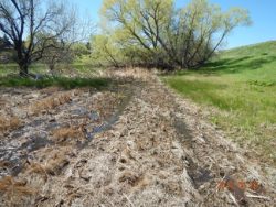
| Active seepage situation at the toe of a dam.
(Image Source: DamFailures.org)
|
Nearly every dam experiences seepage to varying degrees. Depending on the type of dam and its unique site conditions, seepage may go through, underneath, or around the dam. When left unchecked, excessive seepage can lead to problems such as internal erosion and eventual failure of either the dam itself or other vital components of the dam. According to the Association of State Dam Safety Officials (ASDSO), the second most common dam failure incident driver between the years 2010 through 2019 was seepage or internal erosion.[1]
As a result, monitoring the level of seepage experienced by a dam is essential to building a performance history of the dam season to season and year to year against which future observations can be compared. Should anomalies in the real-time seepage data occur, having a well-documented history can help operators, owners, and engineers determine the cause of these anomalies and if they are cause for concern.
“If uncontrolled seepage is observed, then it should be monitored. To monitor seepage, the following should be recorded: the location of all seepage exit points; seepage flow rates and clarity; the occurrence of recent precipitation that could account for what appears to be seepage, or that could affect the appearance and quantity of actual seepage; the level of the reservoir at the time of the observation. Notes, sketches, and photographs are useful in documenting and evaluating seepage conditions. The amount of seepage usually correlates with the level of the reservoir. Generally, as the level of the reservoir rises, the seepage flow rate increases. An increase in a seepage flow rate for a similar reservoir elevation is cause for concern. In some cases, dye can be used to confirm that the reservoir is the source of seepage. A dye test is not a routing procedure. The length of time it takes to conduct a test may vary since the dye may take different amounts of time to penetrate the embankment or foundation. In most cases, records of seepage volumes that correlate with reservoir elevations are needed to show that seepage comes from the reservoir”.[2]
“Seepage collection and discharge systems, including structural drainage systems, must include access points. Construct these systems in a manner that permits inspection and cleanout of drainpipes. Collection systems should include sediment traps and seepage measurement devices such as weirs or flumes, unless excluding these features is justified in design documentation”.[3]
Measurement Devices
Best Practices Resources
 Instrumentation of Embankment Dams and Levees (EM 1110-2-1908) (U.S. Army Corps of Engineers)
Evaluation and Monitoring of Seepage and Internal Erosion (Federal Emergency Management Agency)
Engineering Guidelines for the Evaluation of Hydropower Projects: Chapter 9- Instrumentation and Monitoring (Federal Energy Regulatory Commission)
Design Standards No. 13: Embankment Dams (Ch. 8: Seepage) (Bureau of Reclamation)
Trainings
 On-Demand Webinar: Internal Erosion – Applying Erosion Mechanics From ICOLD Bulletin 164 In Internal Erosion Failure Mode Analyses
On-Demand Webinar: Relearning How to Look at Piezometric Data for Seepage Evaluation
On-Demand Webinar: Evaluation and Maintenance of Piezometers, Relief Wells, and Drains in Dams and Levees
On-Demand Webinar: Seepage Monitoring and Analysis of Embankment Dams
YouTube: Seepage Monitoring and Analysis of Embankment Dams
Citations:
Revision ID: 7290
Revision Date: 07/18/2023
