Breach Parameters: Difference between revisions
No edit summary |
No edit summary |
||
| Line 2: | Line 2: | ||
[[Category:Dam Breach Inundation Analysis]] | [[Category:Dam Breach Inundation Analysis]] | ||
---- | ---- | ||
{{Picture | |||
|image= | |||
<!-- Add image file name --> | |||
Pigg_River_Power_Dam_Breach.jpg | |||
|link= | |||
|caption= | |||
<!-- Add picture caption --> | |||
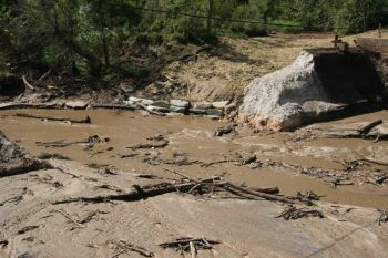
Pigg River Power Dam Breach. | |||
(Image Source: [https://commons.wikimedia.org/wiki/File:Pigg_River_Power_Dam_Breach_-_Day_27_(31516587621).jpg Wikimedia]) | |||
}} | |||
<!-- Delete any sections that are not necessary to your topic. Add pictures/sections as needed --> | <!-- Delete any sections that are not necessary to your topic. Add pictures/sections as needed --> | ||
“Dam breach modeling can be divided into two categories, each of which has a number of models, tools, or equations, ranging from simple to advanced: (1) tools that generate the dam breach peak discharge and/or hydrograph only; and (2) tools that develop a breach hydrograph and perform downstream flood routing using a one- or two-dimensional hydraulic model.” <ref name ="FEMA P-946">[[Federal Guidelines for Inundation Mapping of Flood Risks Associated with Dam Incidents and Failures (FEMA P-946) | Federal Guidelines for Inundation Mapping of Flood Risks Associated with Dam Incidents and Failures (FEMA P-946), FEMA, 2013]]</ref> | “Dam breach modeling can be divided into two categories, each of which has a number of models, tools, or equations, ranging from simple to advanced: (1) tools that generate the dam breach peak discharge and/or hydrograph only; and (2) tools that develop a breach hydrograph and perform downstream flood routing using a one- or two-dimensional hydraulic model.” <ref name ="FEMA P-946">[[Federal Guidelines for Inundation Mapping of Flood Risks Associated with Dam Incidents and Failures (FEMA P-946) | Federal Guidelines for Inundation Mapping of Flood Risks Associated with Dam Incidents and Failures (FEMA P-946), FEMA, 2013]]</ref> | ||
Latest revision as of 18:35, 21 July 2023

|
| Pigg River Power Dam Breach.
(Image Source: Wikimedia) |
“Dam breach modeling can be divided into two categories, each of which has a number of models, tools, or equations, ranging from simple to advanced: (1) tools that generate the dam breach peak discharge and/or hydrograph only; and (2) tools that develop a breach hydrograph and perform downstream flood routing using a one- or two-dimensional hydraulic model.” [1]
“The parameters of failure depend on the dam and the mode of failure. For flood hydrograph estimation, the breach is modeled assuming weir conditions, and the breach size, shape, and timing are the important parameters. The larger the breach opening and the shorter the time to total failure, the larger the peak outflow.” [2]
“The breach is the opening formed in the dam when it fails. Despite the fact that the main modes of failure have been identified as piping or overtopping, the actual failure mechanics are not well understood for either earthen or concrete dams. In previous attempts to predict downstream flooding due to dam failures, it was usually assumed that the dam failed completely and instantaneously. These assumptions of instantaneous and complete breaches were used for reasons of convenience when applying certain mathematical techniques for analyzing dam-break flood waves. The presumptions are somewhat appropriate for concrete arch-type dams, but they are not suitable for earthen dams and concrete gravity-type dams.” [2]
Breach Parameter Definitions
“The following definitions are commonly accepted for use in evaluating and selecting dam breach parameters:
- "Breach formation time (also time-to-failure) – The duration of time between the first breaching of the upstream face of the dam (breach initiation) and when the breach has reached its full geometry.
- "Breach depth (also breach height) – The breach depth is the vertical extent of the breach measured from a specific elevation to the invert of the dam breach.
- "Breach width – The breach width is the average of the final breach width, typically measured at the vertical center of the breach.
- "Breach side slope factor – The breach side slope is a measure of the angle of the breach sides represented as X horizontal to 1 vertical (XH:1V).
“A dam breach usually occurs in two distinct phases starting with the breach initiation followed by the breach formation. During the breach initiation phase, flow through the dam is minor and the dam is not considered to have failed. It may be possible to prevent a dam breach during this phase if flow is controlled. Breach formation begins when the flow through the dam has increased and progressed from the upstream face to the downstream face of the dam, is uncontrolled, and will result in the failure of the dam.” [1]
Published Breach Parameter Estimation Methods
- “Physically Based Erosion Methods – These methods predict the development of an embankment breach and the resulting breach outflows using an erosion model based on principles of hydraulics, sediment transport, and soil mechanics.
- “Parametric Regression Equations – These equations, developed from case study information, are used to estimate the time-to-failure and ultimate breach geometry. The breach can then be simulated to proceed as a time-dependent linear process with the computation breach outflows using principles of hydraulics.
- “Predictor Regression Equations – These equations estimate the dam breach peak discharge empirically based on case study data of peak discharge and hydrograph shape.” [1]
Best Practices Resources
![]() Hydrologic Engineering Requirements for Reservoirs (EM 1110-2-1420), USACE
Hydrologic Engineering Requirements for Reservoirs (EM 1110-2-1420), USACE
Citations:
Revision ID: 7404
Revision Date: 07/21/2023
