Canals: Difference between revisions
No edit summary |
No edit summary |
||
| Line 2: | Line 2: | ||
---- | ---- | ||
<!-- Delete any sections that are not necessary to your topic. Add pictures/sections as needed --> | <!-- Delete any sections that are not necessary to your topic. Add pictures/sections as needed --> | ||
{{Picture | |||
|image= | |||
<!-- Add image file name (ex.image.jpg) --> | |||
canal.jpg | |||
|link= | |||
<!--https://en.wikipedia.org/wiki/Erie_Canal--> | |||
|caption= | |||
<!-- Add picture caption --> | |||
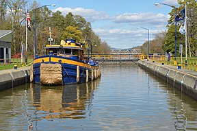
The historic Erie Canal in upstate New York. ([https://en.wikipedia.org/wiki/Erie_Canal Wikipedia]) | |||
}} | |||
“Canals are constructed channels of widely varying capacities used to convey water for irrigation, power, domestic uses, or drainage. Distributory channels conveying water from the main canal to farm units are called laterals and sublaterals. The design capacity of an irrigation canal or lateral is based on maximum daily consumptive use rate downstream of the section under consideration, including allowance for seepage losses. Water loss from seepage is a major problem in canal design. On a typical irrigation project, about 20 to 40 percent of water diverted into the canals and laterals can be expected to be lost be seepage unless lining is provided. Conversely, water seeping into a canal can (under favorable conditions) be used to augment the water supply. Also, inflow seepage is the means by which subsurface draining is accomplished for open-ditch drainage systems”.<ref name="EM1">[[Earth Manual Part 1, 3rd Edition | Earth Manual Part 1, 3rd Edition, USBR, 1998]]</ref> | “Canals are constructed channels of widely varying capacities used to convey water for irrigation, power, domestic uses, or drainage. Distributory channels conveying water from the main canal to farm units are called laterals and sublaterals. The design capacity of an irrigation canal or lateral is based on maximum daily consumptive use rate downstream of the section under consideration, including allowance for seepage losses. Water loss from seepage is a major problem in canal design. On a typical irrigation project, about 20 to 40 percent of water diverted into the canals and laterals can be expected to be lost be seepage unless lining is provided. Conversely, water seeping into a canal can (under favorable conditions) be used to augment the water supply. Also, inflow seepage is the means by which subsurface draining is accomplished for open-ditch drainage systems”.<ref name="EM1">[[Earth Manual Part 1, 3rd Edition | Earth Manual Part 1, 3rd Edition, USBR, 1998]]</ref> | ||
Revision as of 15:35, 16 September 2022

|
| The historic Erie Canal in upstate New York. (Wikipedia) |
“Canals are constructed channels of widely varying capacities used to convey water for irrigation, power, domestic uses, or drainage. Distributory channels conveying water from the main canal to farm units are called laterals and sublaterals. The design capacity of an irrigation canal or lateral is based on maximum daily consumptive use rate downstream of the section under consideration, including allowance for seepage losses. Water loss from seepage is a major problem in canal design. On a typical irrigation project, about 20 to 40 percent of water diverted into the canals and laterals can be expected to be lost be seepage unless lining is provided. Conversely, water seeping into a canal can (under favorable conditions) be used to augment the water supply. Also, inflow seepage is the means by which subsurface draining is accomplished for open-ditch drainage systems”.[1]
“The cross section of a canal is selected to satisfy the most desirable criteria for bottom width, water depth, side slopes, freeboard, and bank dimensions, and to facilitate operation and maintenance. The ratio of bottom width to depth ranges from 2:1 for the smallest laterals to 8:1 for large canals; side slopes on unlined canals range from 1.5h:1v to 2h:1v, or flatter where unstable soils are encountered. Design of canals is based on development of a steady-state seepage condition from the normal high water surface, followed by rapid drawdown of the water surface. Dimensions of the banks and the soils of which they are composed must ensure stability under these extreme hydraulic conditions”.[1]
Best Practices Resources
Citations:
Revision ID: 3412
Revision Date: 09/16/2022
