Two-Dimensional Hydraulic Models: Difference between revisions
From ASDSO Dam Safety Toolbox
(Created page with "__NOTOC__ ---- <!-- Delete any sections that are not necessary to your topic. Add pictures/sections as needed --> One-dimensional models include mathematical simplifications related to the assumption that flood depth remains uniform over the entire cross section. This assumption is not accurate for wide and flat floodplain areas. Two-dimensional models use full dynamic or simplified forms of one- and two-dimensional shallow water equations to solve both one-dimensional c...") |
No edit summary |
||
| Line 2: | Line 2: | ||
---- | ---- | ||
<!-- Delete any sections that are not necessary to your topic. Add pictures/sections as needed --> | <!-- Delete any sections that are not necessary to your topic. Add pictures/sections as needed --> | ||
{{Picture | |||
|image= | |||
<!-- Add image file name (ex.image.jpg) --> | |||
2dmodel.jpg | |||
|link= | |||
<!--https://www.hec.usace.army.mil/--> | |||
|caption= | |||
<!-- Add picture caption --> | |||
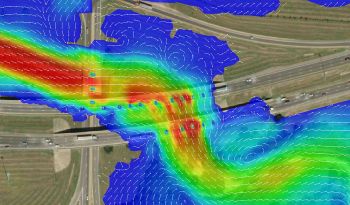
A two-dimensional hydraulic model (Stantec) | |||
}} | |||
One-dimensional models include mathematical simplifications related to the assumption that flood depth remains uniform over the entire cross section. This assumption is not accurate for wide and flat floodplain areas. Two-dimensional models use full dynamic or simplified forms of one- and two-dimensional shallow water equations to solve both one-dimensional channel flow and two-dimensional overland flow and are more appropriate for flat and wide floodplain areas”. <ref name ="FEMA">[[Federal Guidelines for Inundation Mapping of Flood Risks Associated with Dam Incidents and Failures (FEMA P-946) | FEMA P-946 Federal Guidelines for Inundation Mapping of Flood Risks Associated with Dam Incidents and Failures, FEMA, 2013]]</ref> | One-dimensional models include mathematical simplifications related to the assumption that flood depth remains uniform over the entire cross section. This assumption is not accurate for wide and flat floodplain areas. Two-dimensional models use full dynamic or simplified forms of one- and two-dimensional shallow water equations to solve both one-dimensional channel flow and two-dimensional overland flow and are more appropriate for flat and wide floodplain areas”. <ref name ="FEMA">[[Federal Guidelines for Inundation Mapping of Flood Risks Associated with Dam Incidents and Failures (FEMA P-946) | FEMA P-946 Federal Guidelines for Inundation Mapping of Flood Risks Associated with Dam Incidents and Failures, FEMA, 2013]]</ref> | ||
| Line 7: | Line 19: | ||
{{Website Icon}} | {{Website Icon}} | ||
==Best Practices Resources== | ==Best Practices Resources== | ||
{{Document Icon}} | {{Document Icon}} [[Federal Guidelines for Inundation Mapping of Flood Risks Associated with Dam Incidents and Failures (FEMA P-946)]] | ||
==Trainings== | ==Trainings== | ||
{{Video Icon}} | {{Video Icon}} | ||
Revision as of 14:41, 13 September 2022

|
| A two-dimensional hydraulic model (Stantec) |
One-dimensional models include mathematical simplifications related to the assumption that flood depth remains uniform over the entire cross section. This assumption is not accurate for wide and flat floodplain areas. Two-dimensional models use full dynamic or simplified forms of one- and two-dimensional shallow water equations to solve both one-dimensional channel flow and two-dimensional overland flow and are more appropriate for flat and wide floodplain areas”. [1]
Examples
![]()
Best Practices Resources
Trainings
![]()
Citations:
Revision ID: 2791
Revision Date: 09/13/2022
