
Three-Dimensional Hydraulic Models: Difference between revisions
No edit summary |
No edit summary |
||
| Line 11: | Line 11: | ||
|caption= | |caption= | ||
<!-- Add picture caption --> | <!-- Add picture caption --> | ||
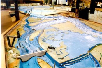
The USACE Bay Model is one of the most famous and most complex physical hydraulic models ever built. While it was once used for scientific research, it is now a tourist attraction. (USACE) | The USACE Bay Model is one of the most famous and most complex physical hydraulic models ever built. While it was once used for scientific research, it is now a tourist attraction. ([https://www.spn.usace.army.mil/Missions/Recreation/Bay-Model-Visitor-Center/The-Bay-Model-Journey/Trekking-the-Model-Tour/ USACE]) | ||
}} | }} | ||
| Line 19: | Line 19: | ||
“Three-dimensional visualization can be a powerful tool for communicating risk and can be easily applied to dam inundation areas. Three-dimensional visualization can provide both experienced and inexperienced users easily recognizable images of an area inundated by water that aid in understanding the magnitude and severity of the event. For example, a standard two-dimensional map typically does not indicate the depth of flooding; the use of graduated colors to represent inundation depths may not convey the true severity of the event to the untrained eye. Three-dimensional visualization can put a new perspective on flood risk with the scale of the disaster being conveyed by overlaying the inundation depths on real life structures such as buildings, bridges, and notable landmarks. Potential applications of three-dimensional visualization are training of emergency officials and public outreach to warn a community of potential dangers. | “Three-dimensional visualization can be a powerful tool for communicating risk and can be easily applied to dam inundation areas. Three-dimensional visualization can provide both experienced and inexperienced users easily recognizable images of an area inundated by water that aid in understanding the magnitude and severity of the event. For example, a standard two-dimensional map typically does not indicate the depth of flooding; the use of graduated colors to represent inundation depths may not convey the true severity of the event to the untrained eye. Three-dimensional visualization can put a new perspective on flood risk with the scale of the disaster being conveyed by overlaying the inundation depths on real life structures such as buildings, bridges, and notable landmarks. Potential applications of three-dimensional visualization are training of emergency officials and public outreach to warn a community of potential dangers. | ||
“Animation can be another valuable tool for communicating the magnitude and response time needed in the event of a dam failure. Many software applications used for dam break modeling provide varying degrees of functionality for animation. For example, HEC-RAS unsteady flow simulations allow the user to animate a flood or dam breach simulation at an individual cross-section or structure level, profile view, or X-Z-Y perspective view using HEC-RAS’s built-in animation control. | “Animation can be another valuable tool for communicating the magnitude and response time needed in the event of a dam failure. Many software applications used for dam break modeling provide varying degrees of functionality for animation. For example, HEC-RAS unsteady flow simulations allow the user to animate a flood or dam breach simulation at an individual cross-section or structure level, profile view, or X-Z-Y perspective view using HEC-RAS’s built-in animation control. | ||
Revision as of 20:31, 13 September 2022
|
| The USACE Bay Model is one of the most famous and most complex physical hydraulic models ever built. While it was once used for scientific research, it is now a tourist attraction. (USACE) |
Three-dimensional hydraulic models are typically used in the study of rapidly-varied flow that occurs along a spillway or bridge pier or in the study of the effects of turbulence and irregular flow geometries on various closed conduit components such as valves or flow meters. There are two types of three-dimensional hydraulic models that can be used, depending on the level of analysis and detail required by the study and available funds.
As a result of the uncertainties in predicting the effects of rapidly-varied flow by using either one- or two-dimensional hydraulic modeling methods, three-dimensional models reduce the uncertainty in this type of turbulent flow and help to achieve a greater level of optimization for a hydraulic design in an engineering project.
“Three-dimensional visualization can be a powerful tool for communicating risk and can be easily applied to dam inundation areas. Three-dimensional visualization can provide both experienced and inexperienced users easily recognizable images of an area inundated by water that aid in understanding the magnitude and severity of the event. For example, a standard two-dimensional map typically does not indicate the depth of flooding; the use of graduated colors to represent inundation depths may not convey the true severity of the event to the untrained eye. Three-dimensional visualization can put a new perspective on flood risk with the scale of the disaster being conveyed by overlaying the inundation depths on real life structures such as buildings, bridges, and notable landmarks. Potential applications of three-dimensional visualization are training of emergency officials and public outreach to warn a community of potential dangers.
“Animation can be another valuable tool for communicating the magnitude and response time needed in the event of a dam failure. Many software applications used for dam break modeling provide varying degrees of functionality for animation. For example, HEC-RAS unsteady flow simulations allow the user to animate a flood or dam breach simulation at an individual cross-section or structure level, profile view, or X-Z-Y perspective view using HEC-RAS’s built-in animation control.
“Although animations would rarely be used in the event of an emergency unless given a large lead time, they can be invaluable tools for training staff identified within an emergency action plan as responders. They can also be an important visualization tool for planners for use in training and in public outreach”.[1]
Examples
![]()
Best Practices Resources
Trainings
![]()
Citations:
Revision ID: 2868
Revision Date: 09/13/2022