
Pre-Modeling Communication: Hydraulic Model Considerations: Difference between revisions
From ASDSO Dam Safety Toolbox
No edit summary |
No edit summary |
||
| (3 intermediate revisions by the same user not shown) | |||
| Line 1: | Line 1: | ||
<!-- Default code to remove table of contents and add line break at top of page --> | |||
__NOTOC__ | |||
<!-- Add Category to drive breadcrumb menus --> | |||
[[Category: Model Work Plan]] | |||
---- | |||
<noautolinks> | |||
<!-- Delete any sections that are not necessary to your topic. Add pictures/sections as needed --> | <!-- Delete any sections that are not necessary to your topic. Add pictures/sections as needed --> | ||
{{Picture | {{Picture | ||
| Line 13: | Line 20: | ||
}} | }} | ||
Prior to performing a hydraulic analysis, the following modeling parameters and key assumptions should be considered and addressed in a model work plan as appropriate: | |||
* State the software selection and describe the limitations of the program as they apply to this project. | * State the software selection and describe the limitations of the program as they apply to this project. | ||
* Describe the hydraulic scenarios to be modeled and any scenario-specific assumptions that will be applied. | * Describe the hydraulic scenarios to be modeled and any scenario-specific assumptions that will be applied. | ||
| Line 19: | Line 27: | ||
* Describe the anticipated model extent and boundary conditions. Also note how model boundaries will be evaluated to assess calculation independence at the location(s) of interest in the model. | * Describe the anticipated model extent and boundary conditions. Also note how model boundaries will be evaluated to assess calculation independence at the location(s) of interest in the model. | ||
* Describe the source of flow data (including base flows, design flows, and hydrographs) and energy loss coefficients. | * Describe the source of flow data (including base flows, design flows, and hydrographs) and energy loss coefficients. | ||
* Describe the model geometry data including | * Describe the model geometry data including terrain data source and resolution as well as bridge, culvert, and other hydraulic structures within the wetted area of the model. | ||
* Summarize information regarding dams, | * Summarize information regarding dams, spillways, and reservoirs where reservoir routing will occur. This should include a description of reservoir routing methodology, initial reservoir levels, stage-storage-discharge curves, and assumed operation of gated spillways or outlet works. Information and assumptions regarding dam breach approach should also be provided if applicable. | ||
* If a parametric sensitivity analysis is planned, describe the approach. | * If a parametric sensitivity analysis is planned, describe the approach. | ||
* Describe the model validation or calibration approach. If historic gage data are used for calibration, provide detailed descriptions of the available information. | * Describe the model validation or calibration approach. If historic gage data are used for calibration, provide detailed descriptions of the available information. | ||
''Development of this page was sponsored by the [[Montana | Montana Department of Natural Resources & Conservation]] with funding from the FEMA Assistance to States Grant Program.'' | |||
<!-- Revision history information --> | |||
{{revhistinf}} | |||
</noautolinks> | |||
Latest revision as of 21:10, 25 June 2024
|
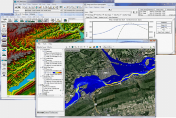
| HEC-RAS is a program commonly used to generate one-dimensional hydraulic models.
(Image Source: Hydrologic Engineering Center, USACE) |
Prior to performing a hydraulic analysis, the following modeling parameters and key assumptions should be considered and addressed in a model work plan as appropriate:
- State the software selection and describe the limitations of the program as they apply to this project.
- Describe the hydraulic scenarios to be modeled and any scenario-specific assumptions that will be applied.
- Note the sources of information and describe the uncertainties or limitations of that information. Also identify data needs and how those gaps will be addressed.
- State whether a steady or unsteady flow condition will be modeled. Also state whether a one-dimensional, two-dimensional, or three-dimensional hydraulic model will be used. Justification should be provided for the selected approach based on project objectives and available data.
- Describe the anticipated model extent and boundary conditions. Also note how model boundaries will be evaluated to assess calculation independence at the location(s) of interest in the model.
- Describe the source of flow data (including base flows, design flows, and hydrographs) and energy loss coefficients.
- Describe the model geometry data including terrain data source and resolution as well as bridge, culvert, and other hydraulic structures within the wetted area of the model.
- Summarize information regarding dams, spillways, and reservoirs where reservoir routing will occur. This should include a description of reservoir routing methodology, initial reservoir levels, stage-storage-discharge curves, and assumed operation of gated spillways or outlet works. Information and assumptions regarding dam breach approach should also be provided if applicable.
- If a parametric sensitivity analysis is planned, describe the approach.
- Describe the model validation or calibration approach. If historic gage data are used for calibration, provide detailed descriptions of the available information.
Development of this page was sponsored by the Montana Department of Natural Resources & Conservation with funding from the FEMA Assistance to States Grant Program.
Revision ID: 8016
Revision Date: 06/25/2024