
Erosion & Scour Mitigation: Difference between revisions
(Created page with "__NOTOC__ ---- <!-- Delete any sections that are not necessary to your topic. Add pictures/sections as needed --> “Degradation – The long-term process by which streambeds and floodplains are lowered in elevation due to the removal of material from the boundary by flowing water. “Aggradation – The long-term process by which streambeds and floodplains are raised in elevation due to the deposition of material eroded and transported from other areas. “Scour...") |
No edit summary |
||
| (11 intermediate revisions by 3 users not shown) | |||
| Line 1: | Line 1: | ||
__NOTOC__ | __NOTOC__ | ||
[[Category:Hydraulics]] | |||
---- | ---- | ||
<!-- Delete any sections that are not necessary to your topic. Add pictures/sections as needed --> | <!-- Delete any sections that are not necessary to your topic. Add pictures/sections as needed --> | ||
{{Picture | |||
|image= | |||
<!-- Add image file name (ex.image.jpg) --> | |||
LocalScour.gif | |||
|link= | |||
<!--https://www.usgs.gov/news/science-snippet/earthword-scour--> | |||
|caption= | |||
<!-- Add picture caption --> | |||
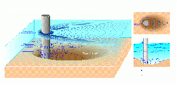
Bridge scour at a cylindrical support. | |||
(Image Source: [https://www.usgs.gov/news/science-snippet/earthword-scour USGS, 2016]) | |||
}} | |||
“'''Degradation''' – The long-term process by which streambeds and floodplains are lowered in elevation due to the removal of material from the boundary by flowing water.<ref name ="USBR">[[Computing Degradation and Local Scour | Computing Degradation and Local Scour, USBR, 1984]]</ref> | |||
“'''Aggradation''' – The long-term process by which streambeds and floodplains are raised in elevation due to the deposition of material eroded and transported from other areas.<ref name ="USBR"/> | |||
“'''Scour''' – The enlargement of a flow section by the removal of boundary material through the action of fluid motion during a single discharge event. The result of the scouring action may or may not be evident after the passing of the flood event”.<ref name ="USBR"/> | |||
“The two basic factors influencing the extent of degradation in a stream channel are: (1) hydraulic properties including river channel velocities, hydraulic gradient or slope, and depth of flow associated with peak discharges and throughout the range in discharges, and (2) particle size distribution of sediments in the channel bed and banks. A careful evaluation of these factors is essential to any degradation analysis. One additional factor is the combination of streambed and valley controls which may exist in the channel reach subject to degradation. The controls may be rock outcrops, cobbles and boulders in the channel, vegetation growing along the banks, or manmade structures which act to control water levels and retard degradation processes. A control in the channel may in some cases prevent any appreciable degradation from occurring above it. Conversely, a change or removal of an existing control may initiate the degradation process”. <ref name ="USBR"/> | |||
< | “Before undertaking any degradation study below a dam, an evaluation is needed of the degree of detail required to complete the study, of the appropriate design data for the dam, and of the future [[environmental]] conditions below the dam." <ref name ="USBR"/> | ||
==Best Practices Resources== | |||
{{Document Icon}} [[Technical Manual: Overtopping Protection for Dams (FEMA P-1015)|Technical Manual: Overtopping Protection for Dams (FEMA P-1015)]] | |||
{{Document Icon}} [[Design Standards No. 13: Embankment Dams (Ch. 7: Riprap Slope Protection)|Design Standards No. 13: Embankment Dams (Ch. 7: Riprap Slope Protection) (Reclamation)]] | |||
{{Document Icon}} [[Design Standards No. 13: Embankment Dams (Ch. 17: Soil-Cement Slope Protection)|Design Standards No. 13: Embankment Dams (Ch. 17: Soil-Cement Slope Protection) (Reclamation)]] | |||
{{Document Icon}} [[Hydraulic Design of Stilling Basins and Energy Dissipators (EM 25)|Hydraulic Design of Stilling Basins and Energy Dissipators (USACE)]] | |||
==Trainings== | |||
{{Video Icon}} [[On-Demand Webinar: Rock Scour Assessment for Dams, Spillways and other Water Conveyance Structures]] | |||
{{Video Icon}} [[On-Demand Webinar: Designing Slope Protection for Dams and Levees]] | |||
{{Video Icon}} [[On-Demand Webinar: Terminal Structures and Energy Dissipation at Outlet Works and Spillways]] | |||
<!-- For information on notation for in text citations visit https://www.mediawiki.org/wiki/Help:Cite Or simply enclose the citation as shown <ref> citation </ref> in the location of the in text mention. Citations will automatically populate below--> | <!-- For information on notation for in text citations visit https://www.mediawiki.org/wiki/Help:Cite Or simply enclose the citation as shown <ref> citation </ref> in the location of the in text mention. Citations will automatically populate below--> | ||
Latest revision as of 20:51, 21 July 2023
|
| Bridge scour at a cylindrical support.
(Image Source: USGS, 2016) |
“Degradation – The long-term process by which streambeds and floodplains are lowered in elevation due to the removal of material from the boundary by flowing water.[1]
“Aggradation – The long-term process by which streambeds and floodplains are raised in elevation due to the deposition of material eroded and transported from other areas.[1]
“Scour – The enlargement of a flow section by the removal of boundary material through the action of fluid motion during a single discharge event. The result of the scouring action may or may not be evident after the passing of the flood event”.[1]
“The two basic factors influencing the extent of degradation in a stream channel are: (1) hydraulic properties including river channel velocities, hydraulic gradient or slope, and depth of flow associated with peak discharges and throughout the range in discharges, and (2) particle size distribution of sediments in the channel bed and banks. A careful evaluation of these factors is essential to any degradation analysis. One additional factor is the combination of streambed and valley controls which may exist in the channel reach subject to degradation. The controls may be rock outcrops, cobbles and boulders in the channel, vegetation growing along the banks, or manmade structures which act to control water levels and retard degradation processes. A control in the channel may in some cases prevent any appreciable degradation from occurring above it. Conversely, a change or removal of an existing control may initiate the degradation process”. [1]
“Before undertaking any degradation study below a dam, an evaluation is needed of the degree of detail required to complete the study, of the appropriate design data for the dam, and of the future environmental conditions below the dam." [1]
Best Practices Resources
![]() Technical Manual: Overtopping Protection for Dams (FEMA P-1015)
Technical Manual: Overtopping Protection for Dams (FEMA P-1015)
![]() Design Standards No. 13: Embankment Dams (Ch. 7: Riprap Slope Protection) (Reclamation)
Design Standards No. 13: Embankment Dams (Ch. 7: Riprap Slope Protection) (Reclamation)
![]() Design Standards No. 13: Embankment Dams (Ch. 17: Soil-Cement Slope Protection) (Reclamation)
Design Standards No. 13: Embankment Dams (Ch. 17: Soil-Cement Slope Protection) (Reclamation)
![]() Hydraulic Design of Stilling Basins and Energy Dissipators (USACE)
Hydraulic Design of Stilling Basins and Energy Dissipators (USACE)
Trainings
![]() On-Demand Webinar: Rock Scour Assessment for Dams, Spillways and other Water Conveyance Structures
On-Demand Webinar: Rock Scour Assessment for Dams, Spillways and other Water Conveyance Structures
![]() On-Demand Webinar: Designing Slope Protection for Dams and Levees
On-Demand Webinar: Designing Slope Protection for Dams and Levees
![]() On-Demand Webinar: Terminal Structures and Energy Dissipation at Outlet Works and Spillways
On-Demand Webinar: Terminal Structures and Energy Dissipation at Outlet Works and Spillways
Citations:
Revision ID: 7428
Revision Date: 07/21/2023